ܠܦܦܐ:Harir.jpg

ܥܓܪܐ ܕܓܠܚܐ: 800 × 600 ܦܩܣܠ. Other resolutions: 320 × 240 ܦܩܣܠ | 640 × 480 ܦܩܣܠ | 1,024 × 768 ܦܩܣܠ | 1,280 × 960 ܦܩܣܠ | 2,560 × 1,920 ܦܩܣܠ | 3,264 × 2,448 ܦܩܣܠ.
ܠܦܦܐ ܫܪܫܝܐ (3,264 × 2,448 ܦܩܣܠ، ܥܓܪܐ ܕܠܦܦܐ: 2.87 MB، ܐܕܫܐ ܕ MIME: image/jpeg)
ܦܣܝܩܬ̈ܐ
| Description |
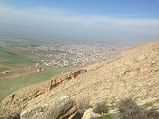
English: The town of Harir, in the Kurdistan Region of Iraq (2016) |
| ܣܝܩܘܡܐ | |
| ܡܒܘܥܐ | Own work |
| ܣܝܘܡܐ | Chaldean |
| Camera location | | View this and other nearby images on: OpenStreetMap |
|---|
ܦܣܣܐ
I, the copyright holder of this work, hereby publish it under the following license:
This file is licensed under the Creative Commons Attribution-Share Alike 4.0 International license.
- You are free:
- to share – to copy, distribute and transmit the work
- to remix – to adapt the work
- Under the following conditions:
- attribution – You must give appropriate credit, provide a link to the license, and indicate if changes were made. You may do so in any reasonable manner, but not in any way that suggests the licensor endorses you or your use.
- share alike – If you remix, transform, or build upon the material, you must distribute your contributions under the same or compatible license as the original.
ܬܫܥܝܬܐ ܕܠܦܦܐ
Click on a date/time to view the file as it appeared at that time.
| ܣܝܩܘܡܐ/ܙܒܢܐ | ܨܘܪܬܐ ܙܥܘܪܬܐ | ܩܝܡ̈ܐ | ܡܦܠܚܢܐ | ܥܘܩܒܐ | |
|---|---|---|---|---|---|
| ܗܫܝܐ | 16:53, 14 ܒܬܡܘܙ 2017 | | 3,264 × 2,448 (2.87 MB) | Chaldean | Cross-wiki upload from en.wikipedia.org |
ܡܦܠܚܬܐ ܕܠܦܦܐ
ܦܐܬܐ ܗܕܐ ܐܣܪ ܥܡ ܗܢܐ ܠܦܦܐ:
ܡܦܠܚܢܘܬܐ ܓܘܢܝܬܐ ܕܠܦܦܐ
The following other wikis use this file:
- Usage on ar.wikipedia.org
- Usage on arz.wikipedia.org
- Usage on en.wikipedia.org
- Usage on fa.wikipedia.org
- Usage on nn.wikipedia.org
- Usage on pl.wikipedia.org