ܠܦܦܐ:Seine drainage basin.png
ܥܓܪܐ ܕܓܠܚܐ: 737 × 599 ܦܩܣܠ. Other resolutions: 295 × 240 ܦܩܣܠ | 590 × 480 ܦܩܣܠ | 974 × 792 ܦܩܣܠ.
ܠܦܦܐ ܫܪܫܝܐ (974 × 792 ܦܩܣܠ، ܥܓܪܐ ܕܠܦܦܐ: 866 KB، ܐܕܫܐ ܕ MIME: image/png)
ܦܣܝܩܬ̈ܐ
| Description |
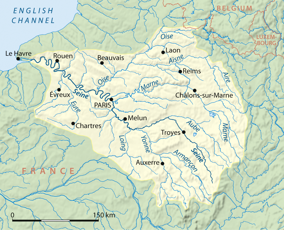
Deutsch: Einzugsgebiet der Seine, englische Version
English: Drainage basin of Seine, English version |
| ܣܝܩܘܡܐ | |
| ܡܒܘܥܐ |
Own work using:
|
| ܣܝܘܡܐ | NordNordWest |
| Other versions |
|

|
This map has been made or improved in the German Kartenwerkstatt (Map Lab). You can propose maps to improve as well.
|
ܦܣܣܐ
I, the copyright holder of this work, hereby publish it under the following licenses:

|
Permission is granted to copy, distribute and/or modify this document under the terms of the GNU Free Documentation License, Version 1.2 or any later version published by the Free Software Foundation; with no Invariant Sections, no Front-Cover Texts, and no Back-Cover Texts. A copy of the license is included in the section entitled GNU Free Documentation License. |
This file is licensed under the Creative Commons Attribution-Share Alike 3.0 Unported license.
- You are free:
- to share – to copy, distribute and transmit the work
- to remix – to adapt the work
- Under the following conditions:
- attribution – You must give appropriate credit, provide a link to the license, and indicate if changes were made. You may do so in any reasonable manner, but not in any way that suggests the licensor endorses you or your use.
- share alike – If you remix, transform, or build upon the material, you must distribute your contributions under the same or compatible license as the original.
You may select the license of your choice.
ܬܫܥܝܬܐ ܕܠܦܦܐ
Click on a date/time to view the file as it appeared at that time.
| ܣܝܩܘܡܐ/ܙܒܢܐ | ܨܘܪܬܐ ܙܥܘܪܬܐ | ܩܝܡ̈ܐ | ܡܦܠܚܢܐ | ܥܘܩܒܐ | |
|---|---|---|---|---|---|
| ܗܫܝܐ | 21:08, 25 ܒܐܕܪ 2008 | | 974 × 792 (866 KB) | NordNordWest | {{Information |Description={{de}} Einzugsgebiet der Seine, englische Version {{en}} Drainage basin of Seine, English version |Source=own work, using * GTOPO-30 Elevation Data by USGS |Date=25-03-2008 |Author= [[User:Titus Groa |
ܡܦܠܚܬܐ ܕܠܦܦܐ
ܦܐܬܐ ܗܕܐ ܐܣܪ ܥܡ ܗܢܐ ܠܦܦܐ:
ܡܦܠܚܢܘܬܐ ܓܘܢܝܬܐ ܕܠܦܦܐ
The following other wikis use this file:
- Usage on af.wikipedia.org
- Usage on ang.wikipedia.org
- Usage on ar.wikipedia.org
- Usage on bg.wikipedia.org
- Usage on bn.wikipedia.org
- Usage on de.wikipedia.org
- Usage on en.wikipedia.org
- Usage on eu.wikipedia.org
- Usage on hr.wikipedia.org
- Usage on is.wikipedia.org
- Usage on ka.wikipedia.org
- Usage on kk.wikipedia.org
- Usage on mk.wikipedia.org
- Usage on pnb.wikipedia.org
- Usage on simple.wikipedia.org
- Usage on sk.wikipedia.org
- Usage on uk.wikipedia.org